GEOTECHNICAL ENGINEERING1
BLENHEIM
HomeInvestigationExploratory test pit

Exploratory Test Pits in Blenheim: Stratigraphic Verification to NZS 3404

Knowledgeable. Thorough. Resourceful.

LEARN MORE

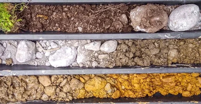
NZS 3404 and the NZGS soil description guidelines form the backbone of any site investigation in Blenheim. The Wairau Plains present a complex alluvial puzzle. What you see at the surface rarely matches what lies below. Exploratory test pit excavation cuts through the guesswork. It lets the engineering team stand inside the profile. They can see the gravel lenses. They can touch the silt layers. They can measure groundwater seepage directly. This is not a remote sensor reading. This is direct, tactile verification. In a region where the Wairau River has shifted course for millennia, the soil can change from clean gravel to soft clay within the length of a single section. A CPT test provides a continuous resistance profile, which is useful for tracking these sudden transitions. But nothing replaces the visual certainty of an open excavation for confirming bearing stratum continuity before a concrete pour.

An open test pit turns a one-dimensional borehole log into a three-dimensional understanding of the ground formation.

Our service areas

How we work

The most common mistake we see in Blenheim is assuming uniform gravels just because the neighbour's section had them. A contractor digs a footing. They hit what looks like good ground. They pour. Six months later, differential settlement cracks the veneer. The problem? A buried paleochannel filled with compressible organic silt ran diagonally through the site. Exploratory test pit investigation maps these hidden features before the excavator bucket touches the foundation line. Our field team logs each pit wall using the NZGS standardized classification. They photograph the strata. They collect bulk disturbed samples for laboratory index testing. We often pair this with grain size analysis to quantify the gravel-to-fines ratio, which directly influences the bearing capacity calculations under NZS 3604. The pit depth typically reaches 3 to 4 metres on the plains, or refusal on the dense gravels of the Rapaura formation. Groundwater inflow is measured if encountered. The log becomes a legal record of the ground conditions at the time of construction.
Exploratory Test Pits in Blenheim: Stratigraphic Verification to NZS 3404
Technical reference — Blenheim

Local considerations

Compare a site near the Taylor River with one out toward Renwick. The river-side site might hit clean, free-draining gravels at 1.2 metres. The Renwick site, just two kilometres away, might find a metre of stiff clay overlying loose sands. These are two entirely different foundation design problems. Exploratory test pit excavation exposes this contrast directly. The risk of ignoring this step is a footing designed for one condition but built on another. In the gravels, the pit walls stand vertical and dry. In the silts, the walls slough and water seeps in at the base. The field engineer sees this. They adjust the drainage specification. They recommend a wider footing or a deeper key. Without the pit, these decisions are made on assumptions. In a seismic region like Marlborough, where the Wairau Fault runs just north of town, the consequences of a wrong assumption are amplified. The pit also reveals buried services, old burn piles, or uncompacted fill that a hand auger would miss entirely.

Need a geotechnical assessment?

Reply within 24h.

Email: contact@geotechnical-engineering1.co

Applicable standards

NZS 3404:2009 (Steel Structures Standard, geotechnical sections), NZS 3604:2011 (Timber-framed buildings, foundation provisions), NZGS Guideline for Field Description of Soils and Rocks (2005), WorkSafe NZ Excavation Safety Guidelines

Technical data

ParameterTypical value
Typical depth range (Wairau Plains)2.5 m to 4.0 m below EGL
Bucket width for stable access600 mm to 900 mm
Excavation methodHydraulic excavator with smooth-edged bucket
In-situ logging standardNZGS Guideline for Field Description (2005)
Sample type collectedBulk disturbed (C1), bagged in 20 kg lots
Groundwater observationInflow rate and stabilized level after 30 min
Backfill compaction controlLayer thickness ≤200 mm, compacted to 95% MDD
Safety complianceWorkSafe NZ Excavation Safety Guidelines (benched or battered sides)

Quick answers

How deep can a test pit go in Blenheim's gravel soils?

In the dense Rapaura gravels that underlie much of Blenheim, test pits typically reach 3 to 4 metres before refusal. The excavator bucket encounters increasing resistance. In the younger Wairau alluvium near the river, pits can sometimes go deeper but groundwater inflow often becomes the limiting factor. The NZGS guidelines recommend benching or battering the sides beyond 1.5 metres for safe entry.

What is the typical cost range for an exploratory test pit in Blenheim?
Do I need a test pit if I already have a CPT or borehole log?

A CPT or borehole gives excellent vertical resolution at a single point. A test pit gives you the lateral picture. It reveals how the layers connect between points. It also lets you see features like fissures, root holes, or gravel lenses that a cone might penetrate without registering. For shallow foundation design under NZS 3604, the combination of a CPT test with a test pit provides the most complete ground model.

How long does a test pit stay open for inspection?

The pit remains open for the duration of the logging and sampling, typically 1 to 2 hours. The field engineer completes the log, takes photographs, and collects samples in that window. The pit is then backfilled immediately with the excavated material, compacted in layers. We do not leave pits open overnight due to safety requirements under the WorkSafe NZ Excavation Safety Guidelines.

Location and service area

We serve projects across Blenheim and surrounding areas.

View larger map